By Mike Koshmrl
Jackson Hole News&Guide
Via Wyoming News Exchange
JACKSON — A 3,000-plus-acre strip of wildland north of the Snake River has been ceded from Teton County to neighboring Lincoln County.
The boundary adjustment isn’t a new one — it was ordered by Wyoming lawmakers in 1965 — but the change in the county line is seeing daylight again due to an ongoing county-led review of Bridger-Teton National Forest property that falls within Teton County, but not Lincoln.
The News&Guide looked into the modest shift in jurisdiction, which forfeited approximately 5.5 of Teton County’s 4,216 square miles, finding that there was no explanation for the change in Wyoming session law or underlying legislation and that the issue did not garner a word of attention in Jackson Hole’s newspaper of the day, the Jackson Hole Guide.
Furthermore, those who wrote the legislation changing the boundary have died, and those who cast their vote on the bill and who are still alive don’t recall what it was about.
At the time, former longtime U.S. Sen. Alan Simpson was a 34-year-old freshman representative in the Wyoming House. He voted for the boundary change.
“I’ve cast 10,000 votes in 40 years on legislation in many forums,” Simpson said, “and I can’t possibly tell you why I voted for each. I don’t remember anything about it. But I do know this: If the delegation for Teton and Lincoln counties were telling me to vote for it, I’d vote for it.”
Teton County Rep. George Hufsmith and Lincoln County Rep. Ed Herschler were both trusted in their day, veteran lawmakers, Simpson said.
The boundary change was not controversial in the Wyoming Legislature as a whole, clearing the House in a 56-to-2 vote. But the Senate version, Senate File 79, stirred some division among the men representing counties 22 and 12. It was jointly introduced by Sens. Harry Barker Jr. and Carl Robinson, of Teton and Lincoln counties, but was opposed by Rep. Allen Campbell, also of Lincoln County. The complete bill can be found with the online version of this article at JHNewsAndGuide.com.
The other representatives from both counties — Herschler and Hufsmith — were on board.
“That means this was something that had been agreed upon by the counties,” Simpson said, “and the counties sold it to the state as something that affects us more than you.”
The bill’s relatively low filing number tells Simpson it was brought up early in the session, and that legislators thought it would pass. Gov. Cliff Hansen, a Teton County native and the grandfather of the present governor, Matt Mead, signed it into law.
A summary of the legislation describes only the Wyoming statutes formulating county boundaries that were being amended, including no reasoning for the adjustment. It goes on to provide an elaborate boundary description for each county, using section and township numbers and geographical landmarks like rivers delineating each jurisdiction.
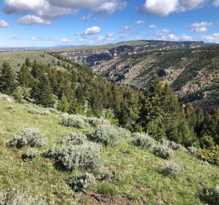
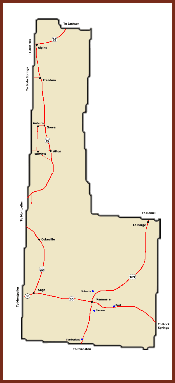
The consequential portion of the description concerns approximately 5.5 sections of land that runs in a strip to the east of Pritchard Pass. It’s located in the high country north of Dog Creek and south of Colburn Creek. Old U.S. Geological Survey topographical maps show the area as being within Teton County, though that’s no longer the case.
The land is entirely managed by the Bridger-Teton National Forest and is undeveloped, bisected by just a lone system trail. For 34 years — since the Wyoming Wilderness Act — it has been managed as a wilderness area, as part of the Palisades Wilderness Study Area. It’s an in-limbo class of land that Teton County is aiming to reclassify through its participation in the Wyoming Public Lands Initiative, a locally led Wyoming County Commissioners Association effort that Lincoln County declined to participate in.
Rich Greenwood, who created and manages Teton County’s GIS map, became aware of the boundary change 15 years ago, when he got an inquiry from a researcher at Chicago’s Newberry Library. He looked into it with help from Teton County Deputy Attorney Keith Gingery, and was baffled.
“It’s the weirdest thing, because it’s all in the forest,” Greenwood said. “They couldn’t have picked a less significant 6 square miles, which makes me think they were trying to sort out some bureaucratic thing.
“With cities we see annexations pretty regularly, like the hillside where the landslide is,” he said. “But it’s less common to see counties change.”
If the transfer of acreage has any effect on anything at all, it’s a slight change in the amount of payment in lieu of taxes, or PILT, dollars each county gets from the U.S. Treasury to make up for nontaxable federal property. Last fiscal year Teton County was awarded $1.94 million for its approximately 2.62 million acres of federal land, which pencils out to about $475 a square mile. That means the boundary adjustment depletes county coffers by around $2,600 annually in recent years.
The shift in county line also prevents Teton County from recommending how the land will be managed through the WPLI process. The Palisades Wilderness Study Area is a focal point of the county review, but the initiative allows only participating counties to address lands within their bounds.
- 39Shares