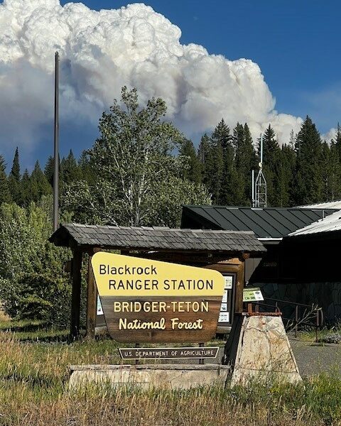
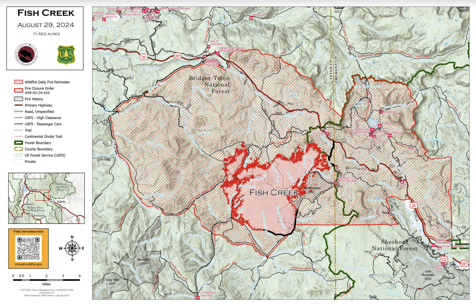
The lightning-caused Fish Creek Fire is now estimated at 34-percent containment according to officials having burned 11,462 acres. The number of personnel has grown to 510 which includes ten hand crews, 22 engines, two dozers, nine pieces of heavy equipment and five helicopters. Officials gave the following update for Thursday August 29.
“The Wyoming Department of Transportation will be conducting traffic control on U.S. Highway 26/287 today while fire crews preemptively cut down hazardous trees along the highway at several locations between mile posts 27 and 31. Motorists should expect intermittent delays during this tree-removal work. If these trees were to catch fire, embers from them could blow across the highway possibly allowing the fire to continue to move north. As these trees burn they could fall onto the highway unexpectedly, creating a dangerous situation for the firefighters and public that might be travelling on the highway.”
The 34 percent complete figure associated with this incident refers to the degree to which the confine/point protection strategic actions have been accomplished. Confine is a wildfire response strategy of restricting a wildfire to a defined area, primarily using natural barriers that are expected to restrict the spread of the wildfire under the prevailing and forecasted weather conditions. Point protection may include the installation of pumps, sprinkler systems, vegetative fuels reduction, and other measures to protect identified values-at-risk.
CURRENT STATUS:
Yesterday, north of the fire area crews continued to work on preparing the Flagstaff Road and Holmes Creek Trail as indirect fire control lines. On the northeast side of the fire an indirect control line from Highway 26 south to Pilot Knob and the Moccasin Basin Trailhead has been completed and ready for use if needed for a tentative burnout operation. South of Brooks Lake Lodge work continued along the Deception Road to construct a shaded fuels break, clearing out ground vegetation and thinning trees for use as a control line. Structure protection crews completed the set up and testing of pumps, hose, and sprinklers in the Brooks, Pinnacle and Breccia areas. All the indirect control line work is being completed as a part of the confine/point protection strategy developed to protect the values at risk closest to the fire.
Today, firefighting resources will continue to improve Holmes Creek Trail, Deception Road, and Flagstaff Road for use as either a control line or to provide point protection. Under favorable fire weather conditions, aerial firing operations may be used to manage fire behavior and spread through a small pocket of heavy fuel on the fire’s east side to prevent fire from spotting across the 2007 Hardscrabble fire scar. Structure protection assessments and plans will continue along the Highway 26 corridor.
WEATHER AND FIRE BEHAVIOR:
Higher pressure will push into the area today. This will lead to temperatures peaking a little warmer, with humidity dropping below 20 percent. Winds will be on the lighter side generally out of the northwest. Gusts of 15 to 20 mph will still be possible along the ridgetops. Warming and drying conditions will continue on Friday.
Active surface fire is expected in the heavy fuels, along with some single tree and or group tree torching. If wind and slope align, short crown fire runs may be seen. If there is any torching near the fire edge, downwind spotting up to three tenths of a mile may be experienced. Fire behavior will increase after a surface inversion lifts around 1000-1100, with fire activity expecting to peak around 1800 and diminishing after dark.
AIR QUALITY AND SMOKE:
The Fish Creek Area, Roads, and Trails Closure Order (map) has been established for public and firefighter safety in the fire area. Full details can also be found at https://www.fs.usda.gov/
Fremont County: Brooks Lake, Pinnacle Drive and Breccia Drive area remain in the Level 2 Evacuation notice. A Level 2 Evacuation means “Be Set” to evacuate. You must prepare to leave at a moment’s notice. This level indicates there is significant danger to your area, and residents should either voluntarily relocate to a shelter or with family/friends outside of the affected area, or if choosing to remain, to be ready to evacuate at a moment’s notice. See the alert notice on the Fremont County Fire Protection District Facebook page.
Teton County: The Teton County Division of Emergency Management utilizes a Ready, Set, Go www.tetoncountywy.gov/1846/
US HWY 26/287 continues to experience smoke and sometimes limited visibility. Wyoming Department of Transportation (WYDOT) is working closely with Fremont County Emergency Management and fire officials for the safety of motorists and firefighters. Drivers are encouraged to visit https://www.wyoroad.info/