
High-resolution radiometric and magnetic data from an airborne geophysical survey of the Medicine Bow Mountains in southern Wyoming are now available to the public. The Wyoming State Geological Survey (WSGS) and U.S. Geological Survey (USGS) collaborated on this survey to better understand the region’s geologic framework and assess its potential for critical and other essential mineral resources. As demand for critical minerals increases, this dataset will be vital for supporting Wyoming’s role in securing these resources, which are essential for modern technologies and national security.
From August through September 2023, helicopters equipped with advanced geophysical instruments flew over approximately 1,050 square miles (2,710 square kilometers) of the Medicine Bow Mountains. The survey focused on the Lake Owen Complex—a Paleoproterozoic layered mafic intrusion known for its platinum group element (PGE) mineralization—and the surrounding area, including the Cheyenne Belt, which marks the southern boundary of the Wyoming Province.
Dr. Erin Campbell, Wyoming State Geologist and Director of the WSGS, emphasized the significance of this dataset for future exploration and research.
“Geophysical surveys like this one are crucial for geologic mapping,” said Campbell. “The data collected will support mineral exploration as well as provide fundamental information on the geologic history of Wyoming.”
The Medicine Bow Mountains have a rich history of mineral exploration and mining, with ongoing interest in resources like copper, gold, nickel, PGEs, vanadium, and others. The survey area covers several mineral systems of interest, including mafic magmatic, magmatic rare earth elements, volcanogenic seafloor, and orogenic gold deposits.
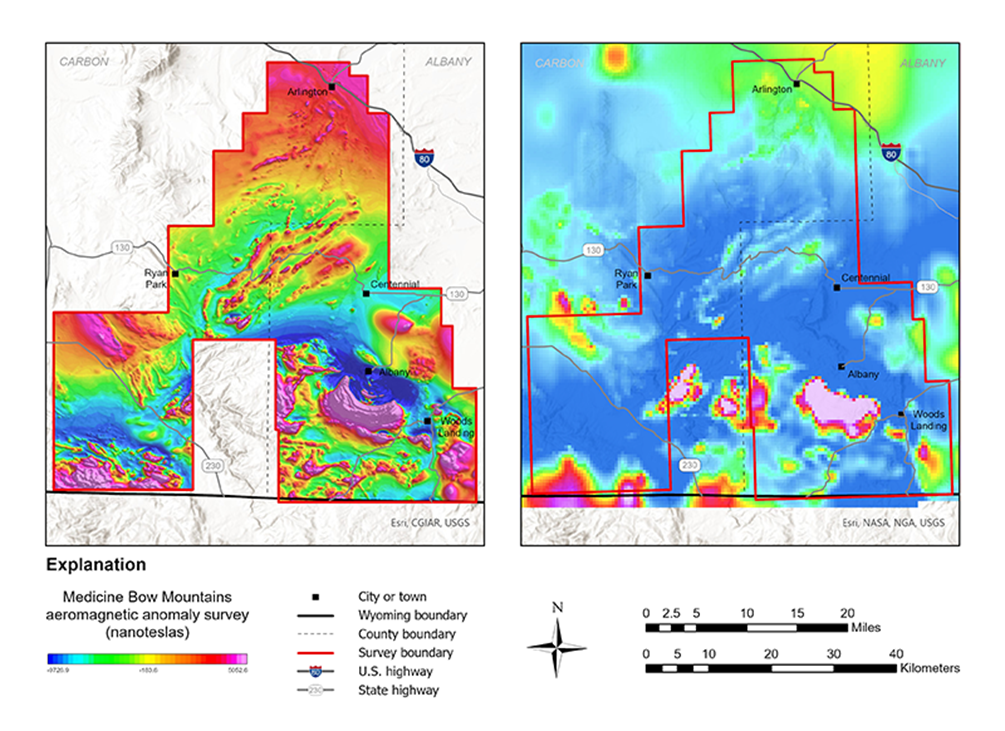
The survey’s high-resolution magnetic data capture variations in the Earth’s magnetic field, revealing subsurface geological structures up to 3,280 feet (1 kilometer) deep. The radiometric data measure natural low-level radiation from rocks near the surface, identifying elements like potassium, uranium, and thorium. These data help geoscientists map geological features and assess the potential for mineral resources.
The survey was conducted under contract by EON Geosciences Inc. and Woolpert Inc., and was jointly funded by the USGS and the State of Wyoming as part of the USGS Earth Mapping Resources Initiative (Earth MRI). Earth MRI is a partnership between the USGS and state geological surveys across the United States to modernize the nation’s geologic framework and improve knowledge of mineral resources.
Processed geophysical data from the Medicine Bow Mountains survey can be downloaded through the USGS at https://doi.org/10.5066/
For more information on these surveys, as well as other Earth MRI projects in Wyoming and throughout the country, visit the Earth MRI Acquisitions Viewer.