Work continues on the Pack Trail Fire which has now burned 89,566 acres and is estimated at 62% contained according to officials. A total of 575 personnel has been used to battle the blaze.
Officials have released the following information for Monday, October 20, 2024.
Operations – On the southwestern flank of the Pack Trail Fire, crews are conducting a tactical firing operation to further protect private property near Buffalo Meadows to the Gros Ventre Valley. Smoke will be visible from Jackson. This tactic is being used to strengthen, straighten and secure the fires edge, diminishing the potential for hotspots to gain heat and momentum, which could make uncontrolled runs toward the containment lines. This tactical firing operation will result in an increase in fire acreage and confinement reported. On the east side, crews will work to mop up 100 feet into the fire’s perimeter to cool down hotspots and connect containment lines from the 540 to 645 road. Crews will complete chipping along the 540 Road and connect containment features above the 635 road. On the north side, crews continue to mop up hotspots and cold trail the fire’s edge.
Safety – Despite the recent precipitation, Teton Interagency Fire Managers are maintaining the Very High Fire Danger Rating for Grand Teton National Park, the Bridger-Teton National Forest, the Shoshone National Forest, and the National Elk Refuge. This precipitation was not a fire season ending event. Due to wind, fuels will begin to rapidly dry out when the snow melts. Any spark can ignite fire which can grow rapidly into a major incident. Residents and visitors are reminded to exercise extreme caution with fires or other possible ignition sources. Keep a shovel, bucket of water or fire extinguisher nearby to quickly control any flare-ups. Preparedness can stop a small spark from becoming a wildfire.
Please use caution while driving these areas, especially on narrow secondary roads. Always expect to encounter fire vehicles and heavy equipment in and around the fire area. Check with WY-DOT for possible closures due to fire activity, especially if you are planning to travel on US-26 across the Continental Divide. Closures are not expected, but with active fire in the area checking status before travel is recommended.
“If you fly, we can’t.” Remember that flying a personal drone over a fire area during a temporary flight restriction is illegal and can be an extremely dangerous threat to both our aviators and firefighters on the ground.
Weather – Today will be partly to mostly cloudy with temperatures of 44-54 degrees with a minimum relative humidity’s between 30% – 40%. Winds from the south-southwest will be 12-17 MPH with gusts up to 30. Warmer and drier weather will return over the week. To learn more about air quality, visit Fire.AirNow.Gov.
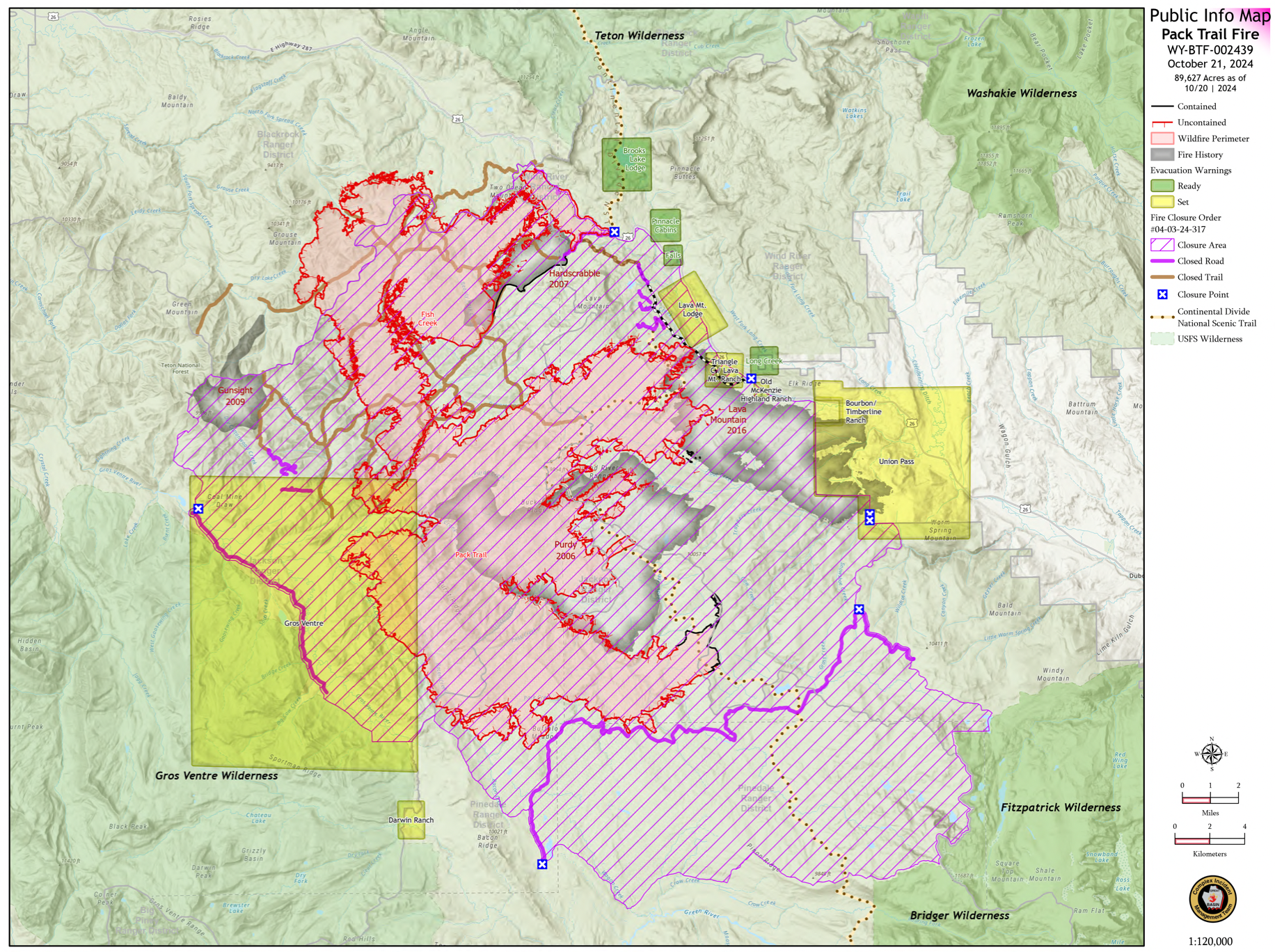
Evacuations – Lava Mountain Lodge, Roaring River Subdivision, Buckboard Subdivision, Double Bar J Ranch, Lava Creek Ranch, Triangle C Ranch, Pelham Lake, Sheridan Creek Camp Areas, Old Mackenzie Ranch, Upper Gros Ventre, Darwin Ranch have been reduced to Level 2 “Set” status. Brooks Lake Lodge, Pinnacle, Breccia, and Long Creek, and Dunior areas have been reduced to a Level 1 “Ready” status. Union Pass subdivision remains in a Level 2 “Set” status. See the Fremont County Emergency Management Facebook Page for alerts and updates. See the Teton County Emergency Management website updates and to sign up for emergency alerts through Everbridge.
Road Closures – The Union Pass Road is closed on the Pinedale Ranger District (BTNF) from Mosquito Lake to the Moon Lake Road on the Wind River District (SHO). Moon Lake Road is also closed.
Forest Closures – Closure Order #04-03-24-317 is in effect from October 14, 2024, at 12:00 p.m. through November 15, 2024 at 12:00 a.m. unless rescinded. This order supersedes previous orders, including #04-03-24-316, prohibiting the same or similar acts in the same described area.
For more information, visit: Facebook: USDA Forest Service – Bridger-Teton National Forest, USDA Forest Service – Shoshone National Forest Pack Trail Inciweb: https://inciweb.wildfire.gov/